Curme East Campsite
Powell River · BC
Source: OpenStreetMap — Canadian campsites · imported Aug 18, 2026
Decide fast
Cost
Fee details available
The source publishes fee information but no exact nightly amount — read the published fee notes below.
Fire conditions
Agency fire orders are checked live — open the section for the current stage and what it allows.
Verified check-in
Checking your traveler account…
Only an approximate position is stored, and never shown to other travelers.
The essentials
Key campground facts
Identity-level facts as published by the source record. Fields no source publishes are left out rather than shown as Unknown.
Price
Fee details availableThe source publishes fee information but no exact nightly amount — read the published fee notes below.
Type
Campground
Camping status
Unknown
Land manager
BC Parks
Sites
12 sites (stated by the source)
Facility phone
1-250-474-1336
Know before you go
No conditions or restrictions are recorded for this location yet. Check the managing agency before you go.
Can you camp here?
Camping legality
Checking land status and camping rules…
Getting there
Access and vehicle suitability
Only what the managing agency or Recreation.gov published. Road surface, clearance, grade and seasonal access are never inferred, and fields no source publishes are left out.
Access statements published by OpenStreetMap — Canadian campsites. Conditions change — verify with the managing agency before you rely on them.
Where it is
Location
Loading map
Placing your camping results on the map.
Province / territory
BC
County
Powell River
Elevation
23 ft
Coordinates
50.11674, -124.74488
Straight from the source
Published record details
Statements the source record publishes, shown as published. Anything it does not publish is left out rather than shown as Unknown.
Park size
8449 ha
Year established
1973
Official park name
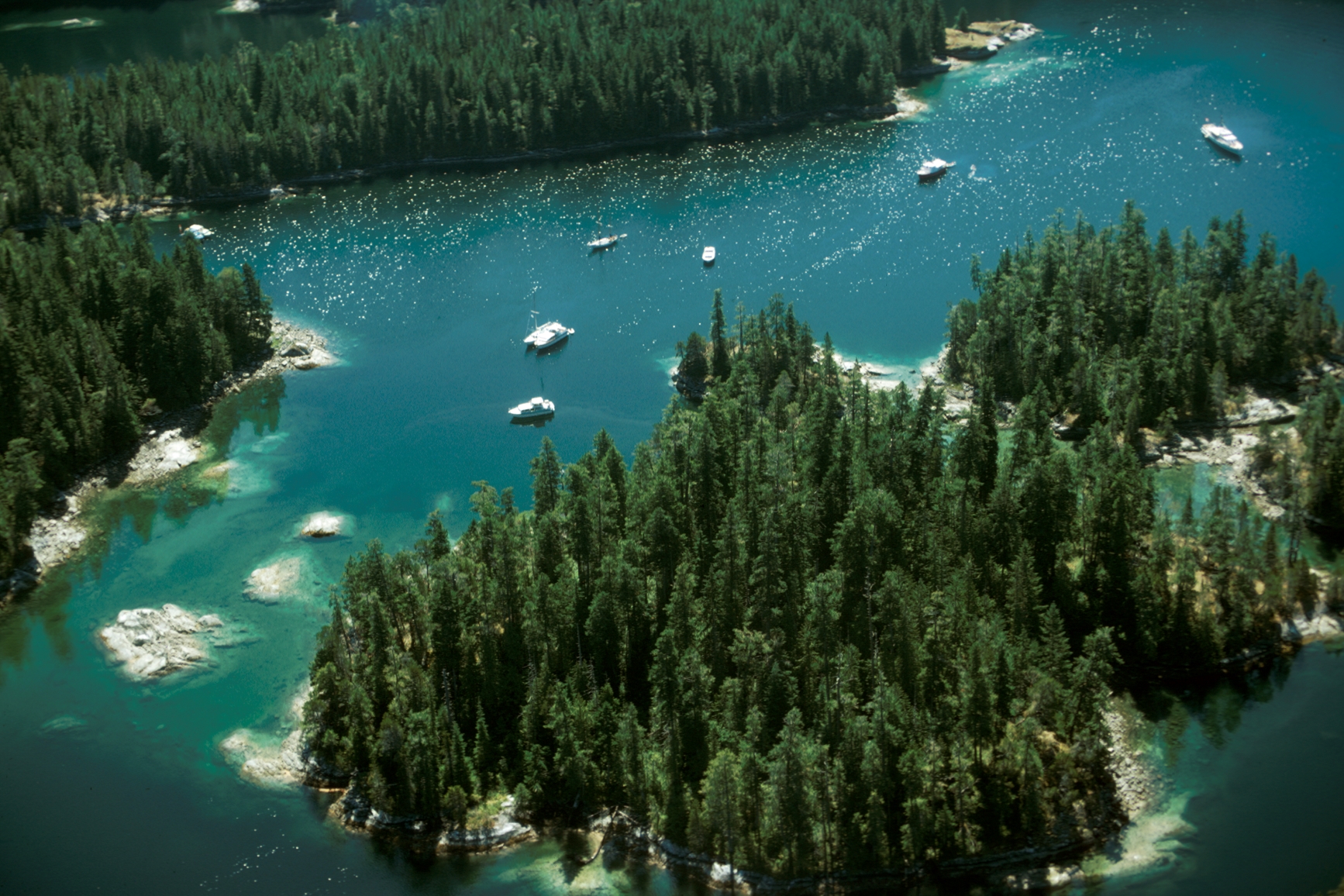
Desolation Sound Marine Park
Park phone
1-250-474-1336
Current notices from the source
Follow 'no anchoring' buoys and signs to protect eelgrass beds — Desolation Sound Marine Park is home to eelgrass habitats that play a crucial role in supporting marine biodiversity. To further our understanding of biodiversity recovery in the region, we are monitoring eelgrass beds with valuable support from the Tla'amin, Klahoose, and Hamalco Nations, and the University of British Columbia. To study these vital habitats, small area closures are in place, marked by ‘no anchoring’ buoys. Around Williams Island, boaters must not anchor in the areas delineated by the ‘no anchoring’ buoys. At Copplestone Island, anchoring is not permitted between the buoys. Our study also includes annual eelgrass monitoring to assess the potential recovery of the eelgrass beds, and evaluate the effectiveness
No campfires permitted — Due to dry windy conditions and the risk of soil erosion, campfires are not permitted anywhere within Desolation Sound Marine Park.
Partial trail closures within Prideaux Haven Anchorage — Portions of established trails within Prideaux Haven Anchorage including the Viewpoint Trail and Melanie Cove Beach Trail are now closed off for recreational use due to ecological restoration. Please respect all signs and fencing identifying closure areas.
Ecological restoration - prohibition on stern tying within Prideaux Haven Anchorage — Stern tying vessels to trees, rocks or other natural objects is prohibited on Scobell and South Williams Islands within Prideaux Haven Anchorage.
Campgrounds in this park
- Bold Head
- East Curme Island
- Grace Harbour
- Hare Point
- South Curme Island
- Tenedos Bay
- West Curme Island
Activities the source lists
- Kayaking
- Swimming
- Pets on leash
- Hiking
- Fishing
- Scuba diving
- Hunting
Facilities as published
- Desolation Sound Marine Park does not have its own boat launch. Okeover Harbour government dock , next to Okeover Arm Park , offers a boat launch with limited free parking. Launching here is only recommended at high tide with four-wheel drive vehicles. Lund Harbour offers a boat launch with private pay parking. Small boating closure areas, marked by ‘no anchoring’ buoys, are in place to protect crucial eelgrass bed habitats.
- Pit toilets are located at Prideaux Haven, Grace Harbor, Tenedos Bay, Curme Islands, Bold Head, Hare Point, Feather Cove, Copeland Islands, and Melanie Cove. There are no flush toilets. Many of the outhouses throughout Desolation Sound are an open-air-privy design. Bring your own toilet paper. Outhouses in Desolation Sound have above-ground pump-out tanks. Due to the shallow soils and potential for exposing cultural features buried in the ground, digging traditional outhouse holes is not possible. Please do not put garbage in the outhouse tanks. They are for human waste only.
Camping information as published
- There are 11 designated campgrounds throughout Desolation Sound, the Copeland Islands, and Malaspina Marine Parks. An average of nine tent pads are available at each campground. For campground locations, download our map of Desolation Sound and Copeland Islands Marine Park designated campsites [PDF] . For more maps, see the maps and location section. To get detailed information about each campground, visit the Desolation Sound Marine Park: Backcountry camping page. For information about launching your boat, see the boat launch section. Marine parks protect sensitive ecosystems. When visiting: Respect boating and anchoring closure areas to protect crucial eelgrass bed habitats. Around Williams Island, boaters must not anchor in the areas marked by the ‘no anchoring’ buoys. At Copplestone Island, anchoring is not permitted between the buoys. Camp only on tent pads and stay on designated trails. Campfires are not permitted throughout Desolation Sound, Copeland Islands, and Malaspina Marine Parks. Marine-accessible camping fees Camping fees (per night) $5 per person (age 6+) Non-resident fee $20 per adult per stay Camping in Desolation Sound Marine Park requires backcountry permit registration . A backcountry permit for Desolation Sound is valid for overnight stays in Desolation Sound Marine Park, Copeland Islands Park, Roscoe Bay Park, and Malaspina Park. Backcountry registration is not a reservation and does not guarantee you a spot. Campsites are available on a first come, first served basis, and cannot be held for other parties. You are encouraged to register online, but you can also pay with cash at Okeover Arm Park or in Lund Harbour . Look for registration information at the BC Parks kiosks. Nearby, Okeover Arm Park offers vehicle-accessible campsites. Many people camp there and get an early start the next day to explore Desolation Sound. You pay a separate fee to camp at Okeover Arm.
Official maps
Amenities
Only amenities the source actually states are listed. Unknown is never shown as No.
Camping
Only camping types present in the source record.
Setting & surroundings
What's around this campsite
Official park information
Published by the land manager as being at or associated with this place. These are stated facts, not measured distances.
Water
Land & terrain
Source: BC Parks (official park data)
Verified nearby features
Loading verified geographic features…
Activities
Sourced only — activities are never inferred.
Environment and Climate Change Canada
Weather
Forecast for the Curme East Campsite coordinates. Values ECCC does not publish stay blank rather than being estimated.
Resolving the ECCC forecast for these coordinates…
Staying reachable
Connectivity
Carrier coverage comes from official FCC filings for this coordinate; Starlink information comes from Starlink's own pages. Nothing here is estimated from terrain, land ownership or nearby towns.
Reading stored coverage sources…
Agency fire orders
Fire conditions
Published fire restriction orders from the managing agency, matched to these exact coordinates. Fire permission is never inferred from land ownership, campground type or weather.
Checking agency fire orders for these coordinates…
Nearby services
Fuel, water, dump, supplies and more
Straight-line distance from the campground coordinates. Mapped places only — never inferred.
Looking up mapped services within 25 miles…
Solar
Off-grid power
Will you make enough power to stay comfortably off-grid here? Modelled from published solar climatology for these exact coordinates, credited in the details.
Modelling solar for these coordinates…
Is this place right for you?
Experience & practicality
Two transparent read-time scores. Unknown facts never count for or against a place, and a score is never used as filter evidence.
Experience
Published recreation and setting.
6.3/ 10
Documented depth: 10 of 16 evidence weight, from 5 published facts. A low number means little is published, not that the place is poor.
Why
- Hiking
- Fishing
- Kayaking / canoeing
- Swimming
- Hunting
Practicality
Published logistics: access, cost, facilities.
—/ 10
Not enough data. Only 2 relevant facts have been published for this record, so no score is shown rather than an invented one.
Why
- Cost is published
- Pets allowed
Partially supported: only one of the two dimensions has enough published evidence, so this record is not presented or ranked as the equal of a fully documented one.
Methodology nmr-score-3.0.0. Park-level activities feed Experience only; campsite facts feed Practicality only. Experience measures how much recreation and setting evidence is published; Practicality is the published positive share scaled by how much of the logistics catalogue has been documented, so a handful of positives can no longer read 10/10. Unknown is never treated as a no. Neither dimension is used to filter search results, and “Best” ordering ranks fully supported records above partially supported ones.
Overview
Why this place?
- Campground.
- Located in Powell River, BC at 23 ft.
- Source lists 5 recreation activities here.
- Fee details are published, but no exact nightly amount — see the fee notes below.
Photos
What it looks like
Imagery published by the managing source for this record, plus verified traveler photos.
Official imagery
Traveler photos
No traveler photos here yet. A photo you upload is reviewed before it appears publicly.
Community · time-sensitive
Community reports
What travelers found on the ground, with the date they were there. Conditions change fast, and a report never replaces the official information above.
Loading community reports
Data & trust
Source confidence
Low
Confidence describes how well the ingested sources agree for this record. Verification is a separate state: Unverified.
Source
OpenStreetMap — Canadian campsites
Last source update
Aug 18, 2026
Source record
#node/9033685285
Community · traveler experience
Traveler reviews
Written by travelers who checked in here. These are personal experiences, not official campsite information, and they never change the sourced facts above.
Loading traveler reviews
Travelers here
Talk with travelers heading to Curme East Campsite. Community conversation — not verified site information. Report conditions through the report form so they can be checked.