
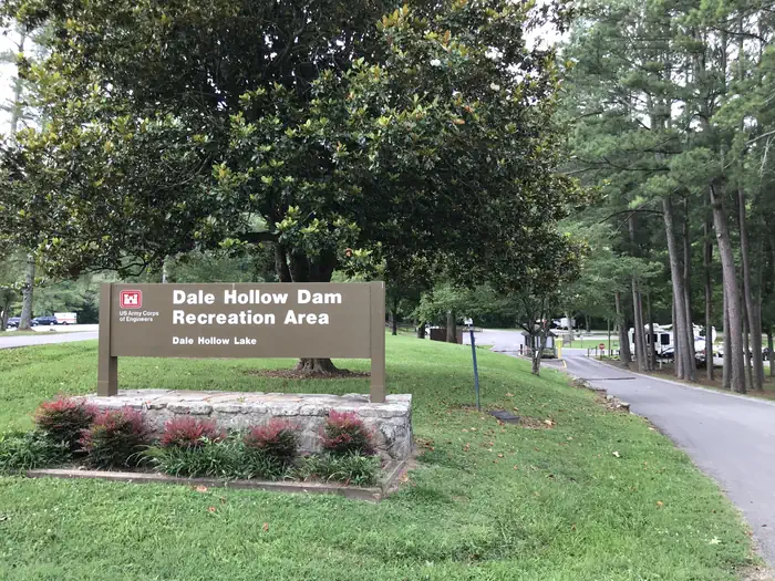
DALE HOLLOW DAMSITE
Celina · Clay County · TN
Source: Recreation.gov · imported Aug 15, 2026
Decide fast
Cost
Fee details available
The source publishes fee information but no exact nightly amount — read the published fee notes below.
Fire conditions
Agency fire orders are checked live — open the section for the current stage and what it allows.
Verified check-in
Checking your traveler account…
Only an approximate position is stored, and never shown to other travelers.
The essentials
Key campground facts
Identity-level facts as published by the source record. Fields no source publishes are left out rather than shown as Unknown.
Price
Fee details availableThe source publishes fee information but no exact nightly amount — read the published fee notes below.
Type
Campground
Camping status
Official campsite
Land manager
US Army Corps of Engineers
Sites
80 campsite records
Reservable sites
77 of the records read
Reservation
Required
Check-in
3:00 Pm
Check-out
2:00 Pm
Facility phone
931-243-3554 CAMPGROUND; 931-243-3136 RESOURCE MANAGEMENT OFFICE, DALE HOLLOW LAKE
Know before you go
- Reservation required before arrival.
Can you camp here?
Camping legality
Checking land status and camping rules…
Getting there
Access and vehicle suitability
Only what the managing agency or Recreation.gov published. Road surface, clearance, grade and seasonal access are never inferred, and fields no source publishes are left out.
Will my vehicle fit?
RV
Yes
Source: Recreation.gov
Trailer
Yes
Source: Recreation.gov
Published dimensions
Longest vehicle a campsite accepts
99 ft
Applies to: Campsite records — what an individual site accepts
Source: Recreation.gov
Vehicles allowed per site
4
Source: Recreation.gov
Permitted equipment
FIFTH WHEEL, PICKUP CAMPER, POP UP, RV, Tent, Trailer
Applies to: Campsite records — what an individual site accepts
Source: Recreation.gov
Roads and route
Road surface
Paved
Accessibility
ADA access published
No
Source: Recreation.gov
Accessible campsites
4
Source: Recreation.gov
Access statements published by Recreation.gov. Conditions change — verify with the managing agency before you rely on them.
Where it is
Location
Loading map
Placing your camping results on the map.
State
TN
County
Clay County
Nearest city
Celina
Elevation
546 ft
Coordinates
36.53778, -85.45694
Site-level source data
Campsite specifications
80 of 80 Recreation.gov campsite records read. The figures below describe the 73 standard, individually bookable campsite records. 4 group site records and 3 management records are reported separately. Every line states how many records reported it.
Electric hookups
72 of 73 sites have electric · 1 of 73 sites report no electric
All 73 site records state a value.
Amperage
50 amp
Published by 72 of 73 site records.
Water hookups
72 of 73 sites have a water hookup
1 site publishes no value for this field, so it is not a campground-wide answer.
Site length limits vary
20 to 99 ft depending on the site
Published by 73 of 73 site records. The campground ceiling is in Access and vehicle suitability.
Site length
29 to 117 ft
Published by 73 of 73 standard site records; the rest publish no dimension.
Site width
9 to 25 ft
Published by 72 of 73 standard site records; the rest publish no dimension.
People per site
Up to 6 people
Published by 73 of 73 site records.
Group sites
4 records
Group sites are booked as a whole area and are excluded from the per-site figures above.
Straight from the source
Published record details
Statements the source record publishes, shown as published. Anything it does not publish is left out rather than shown as Unknown.
Published use types
Day, Overnight
Published campsite types
GROUP SHELTER ELECTRIC, GROUP STANDARD ELECTRIC, MANAGEMENT, RV ELECTRIC, STANDARD ELECTRIC, STANDARD NONELECTRIC
Published amperage
30A, 50A
Park phone
931-243-3554 CAMPGROUND; 931-243-3136 RESOURCE MANAGEMENT OFFICE, DALE HOLLOW LAKE
Amenities
Only amenities the source actually states are listed. Unknown is never shown as No.
Camping
Only camping types present in the source record.
Setting & surroundings
What's around this campsite
Official park information
Published by the land manager as being at or associated with this place. These are stated facts, not measured distances.
Water
Land & terrain
Source: Recreation.gov
Verified nearby features
Loading verified geographic features…
Scenery
What's around you
Activities
Sourced only — activities are never inferred.
National Weather Service
Weather
Forecast for the DALE HOLLOW DAMSITE coordinates. Values NWS does not publish stay blank rather than being estimated.
Resolving the NWS forecast for these coordinates…
Staying reachable
Connectivity
Carrier coverage comes from official FCC filings for this coordinate; Starlink information comes from Starlink's own pages. Nothing here is estimated from terrain, land ownership or nearby towns.
Reading stored coverage sources…
Agency fire orders
Fire conditions
Published fire restriction orders from the managing agency, matched to these exact coordinates. Fire permission is never inferred from land ownership, campground type or weather.
Checking agency fire orders for these coordinates…
Nearby services
Fuel, water, dump, supplies and more
Straight-line distance from the campground coordinates. Mapped places only — never inferred.
Looking up mapped services within 25 miles…
Solar
Off-grid power
Will you make enough power to stay comfortably off-grid here? Modelled from published solar climatology for these exact coordinates, credited in the details.
Modelling solar for these coordinates…
Is this place right for you?
Experience & practicality
Two transparent read-time scores. Unknown facts never count for or against a place, and a score is never used as filter evidence.
Experience
Published recreation and setting.
5.9/ 10
Documented depth: 9.5 of 16 evidence weight, from 4 published facts. A low number means little is published, not that the place is poor.
Why
- Hiking
- River at the site
- Fishing
- Mountain biking
Practicality
Published logistics: access, cost, facilities.
9.1/ 10
91% of the 11 published facts are positive, scaled by how much is documented (100% of the 16-weight target). Partial data coverage · 16 still unpublished. A thin record reads low because little is published, not because the place is poor.
Why
- Camping is published as allowed
- Paved or gravel access road
- Drinking water
- Cost is published
- Electric hookup
- RV friendly
- Maximum vehicle length published
- Pets allowed
- Trailer friendly
- Picnic table
Published as not available
- No reservation required
Fully supported: both dimensions earned a score from 15 published facts.
Methodology nmr-score-3.0.0. Park-level activities feed Experience only; campsite facts feed Practicality only. Experience measures how much recreation and setting evidence is published; Practicality is the published positive share scaled by how much of the logistics catalogue has been documented, so a handful of positives can no longer read 10/10. Unknown is never treated as a no. Neither dimension is used to filter search results, and “Best” ordering ranks fully supported records above partially supported ones.
Overview
Why this place?
- Campground managed by US Army Corps of Engineers.
- Camping status: Official campsite.
- Located in Celina, Clay County, TN at 546 ft.
- Source lists 3 recreation activities here.
- Fee details are published, but no exact nightly amount — see the fee notes below.
- A reservation is required.
Photos
What it looks like
Imagery published by the managing source for this record, plus verified traveler photos.
Official imagery
Traveler photos
No traveler photos here yet. A photo you upload is reviewed before it appears publicly.
Community · time-sensitive
Community reports
What travelers found on the ground, with the date they were there. Conditions change fast, and a report never replaces the official information above.
Loading community reports
Official source
Fees and reservation source material
Retrieved from the Recreation Information Database for this exact facility. Facility facts are listed once in Key campground facts; this block holds the published fee text and the source date check.
Fee notes from Recreation.gov
Payment will be limited to online or credit card transactions only.
Free text as published. It is never converted into a nightly price.
Data & trust
Source confidence
High
Confidence describes how well the ingested sources agree for this record. Verification is a separate state: Unverified.
Source
Recreation.gov
Last source update
Aug 16, 2026
Source record
#232564
- Unverified · RIDB · Aug 15, 2026
Community · traveler experience
Traveler reviews
Written by travelers who checked in here. These are personal experiences, not official campsite information, and they never change the sourced facts above.
Loading traveler reviews
Travelers here
Talk with travelers heading to DALE HOLLOW DAMSITE. Community conversation — not verified site information. Report conditions through the report form so they can be checked.
Nearby and related camping
- PLEASANT GROVE RECREATION AREAClay County · TN · 1 mi away
- DALE HOLLOW LAKE - PRIMITIVE CAMPINGClay County · TN · 2 mi away
- WILLOW GROVE CAMPGROUNDClay County · TN · 7 mi away
- LILLYDALE CAMPGROUND AND DAY USEClay County · TN · 10 mi away
- Sulphur Creek MarinaCumberland County · TN · 11 mi away
- Dale Hollow Lake State ParkCumberland County · TN · 11 mi away