
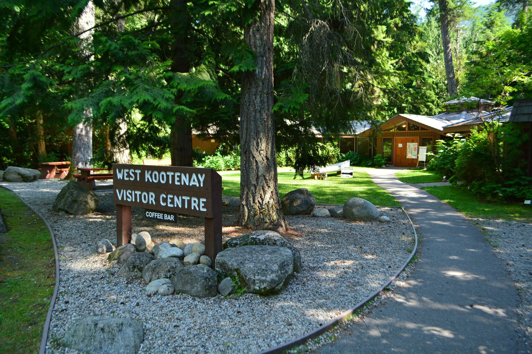
Friends Campground And Day Use
Central Kootenay · BC
Source: OpenStreetMap — Canadian campsites · imported Aug 17, 2026
Decide fast
Fire conditions
Agency fire orders are checked live — open the section for the current stage and what it allows.
Verified check-in
Checking your traveler account…
Only an approximate position is stored, and never shown to other travelers.
The essentials
Key campground facts
Identity-level facts as published by the source record. Fields no source publishes are left out rather than shown as Unknown.
Price
Price not published
Type
Campground
Camping status
Unknown
Land manager
RAP Park Contracting Ltd.
Sites
38 sites (stated by the source)
Facility phone
+1-250-825-4212
Know before you go
No conditions or restrictions are recorded for this location yet. Check the managing agency before you go.
Can you camp here?
Camping legality
Checking land status and camping rules…
Getting there
Access and vehicle suitability
No source publishes road or vehicle information for this location. Road conditions and clearance are never estimated — contact the managing agency before towing or driving in.
Where it is
Location
Loading map
Placing your camping results on the map.
Province / territory
BC
County
Central Kootenay
Elevation
1,759 ft
Coordinates
49.60711, -117.11728
Straight from the source
Published record details
Statements the source record publishes, shown as published. Anything it does not publish is left out rather than shown as Unknown.
Park size
260 ha
Year established
1955
Official park name
Kokanee Creek Park
Park phone
+1-250-825-4212
Current notices from the source
Volunteer Host Opportunity — Kokanee Creek Provincial Park offers volunteer host opportunities.
Kokanee Creek Spawning Channel Area restrictions — Kokanee Creek Spawning Channel restrictions are in place from August 15 to September 30, to improve public safety and provide viewing opportunities of Kokanee spawning in the channel. Thank you for observing all signs. Kokanee Creek Spawning Channel Area restrictions include: Dogs will not be permitted on the channel boardwalk or trails adjacent to the spawning channel. Bicycles must be walked across the boardwalk and along the trails adjacent to the spawning channel. The portion of the spawning channel downstream of the viewing platform will be closed to the public during the period when bears are utilizing it for feeding. This closure will include the trails behind the Nature Centre.
Clean all boats and equipment to prevent the spread of aquatic invasive species — Thank you for your helping prevent invasive species from spreading into this park. Before you arrive: Make sure your boat and all your equipment and clothing are completely clean and completely dry This includes waders, boots, fishing rods and lines Before storage or moving to another body of water: Drain all water from your boat, and remove all plants, animals, and mud Clean and dry your boat and all equipment and clothing Wash your pets if they have been swimming Report sightings of invasive species Never move plants, animals, mud, or water between water bodies. This includes all fish and fish parts. Learn more about invasive aquatic species and how to spot them
Campgrounds in this park
- Friends Campground
- Groupsite G1
- Osprey Point Campground (G2)
- Osprey Point Campground
- Redfish Campground
- Sandspit Campground lanes 1-3, sites 1-52
- Sandspit Campground lanes 4-6, sites 53-113
Activities the source lists
- Hiking
- Swimming
- Fishing
- Canoeing
- Interpretive programs
- Wildlife viewing
- Pets on leash
- Cycling
- Waterskiing
- Windsurfing
- Winter recreation
Facilities as published
- The Holt Shelter is a designated rest spot for cycle tourers and through-hikers, available on a first come, first served basis. Guests may need to share the space with fellow hikers and cyclists. Registration is required upon arrival at the gatehouse.
- There are two day-use and picnic areas both located on Kootenay Lake. The most popular is situated beside the north end of Sandspit campground. The beach is sandy, 1km long and has a wonderful large sandbar at its south-eastern tip. There are several picnic tables along the shore line, 60 feet from the waters edge, evenly spaced among cotton wood and pine trees. The trees offer limited shade and the beach can become very hot during mid day. Behind the tables is a large, open grassy area suitable for recreational sports and family gatherings. Nearby and conveniently located are an adventure playground, toilet change house, pit toilet and two barbeque stands. Parking is available for 120 vehicles. If you want tables by the beach, come early as this beach is popular with local residents. The smaller day-use and picnic area is the Redfish site. The access road is directly across from the Redfish campground entrance on the opposite side of Highway 3. A short drive will bring you to the 40 vehicle parking lot. This location is also where you will find the group picnic and group campsite with the shelter and grassy area. The beach is just a short walk from here and is approximately 300 metres long, described as a mixture of rough sand and gravel. There is no recognized swimming area or change house. A universal pit toilet is close to the beach and a water tap is in the adjacent Osprey Campground. Both these day-use and picnic areas are popular but please remember there are no fire p
- Sandspit campground has three toilet buildings, the day-use and picnic area has one toilet and change house and a pit toilet. Redfish campground has one toilet building and a pit toilet. Redfish day-use and picnic area shares the pit toilets with the group sites.
- Showers are available at the central toilet building in Sandspit campground located between Osprey and Chipmunk Lanes and at the toilet building in the Friends campground.
- Cold well water is available for cooking and drinking. Nine taps are randomly located in both campgrounds. Sandspit day-use and picnic area has two water fountains. Redfish day-use and picnic area shares a water tap with the group sites. Taps are shut off during the off-season.
- Accessibility information is available for this park.
- A large adventure playground with swing set, monkey bars, slide, spring horses, and platforms is located between the Sandspit campground and day-use area. The equipment is set in pea gravel with benches and tables nearby for resting or picnicking. On one edge is a large grassy area suitable for other recreational opportunities.
- A wharf to assist with launching and singlewide concrete boat launch can be found at the north-east end of the Sandspit day-use and picnic area. The 20 unit day-use parking lot can accommodate vehicles or boat trailers; no overnight parking except for registered campers. A nearby marina will keep your boat overnight. Both water skiing and windsurfing are popular activities on Kootenay Lake. Note: Low water levels preclude boat launch use in March and April.
- A sani-station is available during the collecting season is located at the Sandspit campground. The entrance is to the right of campsite #70. Sani-station use fee: $5.00 per discharge
- Electrical service is available in 13 sites at the Friends campground. An additional service charge of $7.00, per night, applies to these sites regardless of whether electrical service is used. Please note: There are no fire rings in sites 137-145.
- While campfires are allowed and campfire rings are provided at each campsite, we encourage visitors to conserve wood and protect the environment by minimizing the use of fire and using campstoves instead. Firewood can be purchased in the park or you may bring your own wood. Fees for firewood are set locally and may vary from park to park. To preserve vegetation and ground cover, please don’t gather firewood from the area around your campsite or elsewhere in the park (this is a ticketable offence under the Park Act). Dead wood is an important habitat element for many plants and animals and it adds organic matter to the soil.
Camping information as published
- Kokanee Creek Park has four campgrounds, Sandspit, Redfish, Osprey Point, and the Friends campground, that offer vehicle-accessible sites. Sandspit, the largest, is located just east of the Kokanee Creek bridge on Highway 3A, while Redfish is located just west of the bridge. The Friends campground is located by the Sandspit day-use and picnic area. Sandspit campgound is where the majority of the facilities are concentrated. After you exit Highway 3 turn right to the park gatehouse. Staff are available to check reservations and direct you to a campsite. This campground is situated in a diverse forest of both conifers (cedar, hemlock, pine) and deciduous (cottonwood, birch, aspen) trees. The mixed forest provides plenty of shade. A blend of medium to large sites can accommodate large rigs and extra vehicles. The campsites, with 18 doubles, are evenly spaced on four parallel lanes called Gopher, Osprey, Chipmunk and Porcupine. These lanes bisect the outer lane referred to as Park Lane. Redfish campground has intimate, mostly shaded, small vehicle accessible sites within a cedar hemlock forest. Two of the sites have tent pads but there are no pull through or doubles. Osprey Point has a mix of sun and shaded sites, equipped with tent pads, picnic tables and fire pits and is situated within a cedar, hemlock, birch and cottonwood forest. A communal picnic shelter with running water, dish pit, picnic tables and an air-tight stove is available for all to use. The adjacent Redfish Beach is easily accessed for kayaks, canoes and paddleboards. There is a dog beach in the south west corner. Please respect the Park boundary and keep dogs under control at all times. Friends campground offers 39 sites close to the main beach, 13 sites have electrical service. Sites 137 to 145 have 30 Amp service and sites 147, 149, 151 and 153 have 30 and 50 Amp service. Please note: There are no fire rings at sites 137 to 145. Services are offered in the high use season between May and September.
- Group sites can be reserved through the BC Parks reservation system . Groupsite G1 Groupsite G1 is located adjacent to the Redfish day-use parking lot and can accommodate 50 visitors for camping and picnicking (must be reserved for both activities) This site is a large circle of 8 picnic tables, large fire pit, water taps, grey water pit and can accommodate up to 8 trailers and multiple tents. Easy access to the Redfish beach. Osprey Point Campground G2 Osprey Point Campground is available as individual campsites during the peak season, but the entire campground can be booked as a groupsite (G2) in the shoulder seasons. There is a communal enclosed picnic shelter equipped with running water, dish pit, steel counter, an air tight stove and picnic tables. Group camping fees Regular group rate (per night) $120 base fee $5 per adult (16+) for minimum 15 adults $1 per youth (6-15) Free for children under 6 Youth group rate (per night) $1 per person for minimum 12 people $50 minimum, $150 maximum Non-resident fee $20 per group per stay Additional fees apply for reservations. For more information on fees and on qualifying for different rates, visit the camping fees page. To qualify for youth group camping, your party must be associated with a school, recreation centre, or non-profit youth organization located in B.C. To learn more, see the group camping page.
Official maps
Amenities
Only amenities the source actually states are listed. Unknown is never shown as No.
Camping
Only camping types present in the source record.
Setting & surroundings
What's around this campsite
Official park information
Published by the land manager as being at or associated with this place. These are stated facts, not measured distances.
Water
Land & terrain
Source: BC Parks (official park data)
Verified nearby features
Loading verified geographic features…
Activities
Sourced only — activities are never inferred.
Environment and Climate Change Canada
Weather
Forecast for the Friends Campground And Day Use coordinates. Values ECCC does not publish stay blank rather than being estimated.
Resolving the ECCC forecast for these coordinates…
Staying reachable
Connectivity
Carrier coverage comes from official FCC filings for this coordinate; Starlink information comes from Starlink's own pages. Nothing here is estimated from terrain, land ownership or nearby towns.
Reading stored coverage sources…
Agency fire orders
Fire conditions
Published fire restriction orders from the managing agency, matched to these exact coordinates. Fire permission is never inferred from land ownership, campground type or weather.
Checking agency fire orders for these coordinates…
Nearby services
Fuel, water, dump, supplies and more
Straight-line distance from the campground coordinates. Mapped places only — never inferred.
Looking up mapped services within 25 miles…
Solar
Off-grid power
Will you make enough power to stay comfortably off-grid here? Modelled from published solar climatology for these exact coordinates, credited in the details.
Modelling solar for these coordinates…
Is this place right for you?
Experience & practicality
Two transparent read-time scores. Unknown facts never count for or against a place, and a score is never used as filter evidence.
Experience
Published recreation and setting.
7.5/ 10
Documented depth: 12 of 16 evidence weight, from 6 published facts. A low number means little is published, not that the place is poor.
Why
- Hiking
- Fishing
- Kayaking / canoeing
- Swimming
- Boating
- Wildlife watching
Practicality
Published logistics: access, cost, facilities.
—/ 10
Not enough data. Only 3 relevant facts have been published for this record, so no score is shown rather than an invented one.
Why
- Cost is published
- Electric hookup
- Pets allowed
Partially supported: only one of the two dimensions has enough published evidence, so this record is not presented or ranked as the equal of a fully documented one.
Methodology nmr-score-3.0.0. Park-level activities feed Experience only; campsite facts feed Practicality only. Experience measures how much recreation and setting evidence is published; Practicality is the published positive share scaled by how much of the logistics catalogue has been documented, so a handful of positives can no longer read 10/10. Unknown is never treated as a no. Neither dimension is used to filter search results, and “Best” ordering ranks fully supported records above partially supported ones.
Overview
Why this place?
- Campground managed by RAP Park Contracting Ltd..
- Located in Central Kootenay, BC at 1,759 ft.
- Source lists 7 recreation activities here.
- No source publishes pricing for this location, so cost is unknown.
Photos
What it looks like
Imagery published by the managing source for this record, plus verified traveler photos.
Official imagery
Traveler photos
No traveler photos here yet. A photo you upload is reviewed before it appears publicly.
Community · time-sensitive
Community reports
What travelers found on the ground, with the date they were there. Conditions change fast, and a report never replaces the official information above.
Loading community reports
Data & trust
Source confidence
Low
Confidence describes how well the ingested sources agree for this record. Verification is a separate state: Unverified.
Source
OpenStreetMap — Canadian campsites
Last source update
Aug 18, 2026
Source record
#way/544673606
Community · traveler experience
Traveler reviews
Written by travelers who checked in here. These are personal experiences, not official campsite information, and they never change the sourced facts above.
Loading traveler reviews
Travelers here
Talk with travelers heading to Friends Campground And Day Use. Community conversation — not verified site information. Report conditions through the report form so they can be checked.
Nearby and related camping
- Sandspit CampgroundCentral Kootenay · BC · 0 mi away
- Redfish CampgroundCentral Kootenay · BC · 1 mi away
- Group CampgroundCentral Kootenay · BC · 1 mi away
- ROSS-WHITE LADY LKCentral Kootenay · BC · 4 mi away
- Six Mile Lakes Recreation SiteCentral Kootenay · BC · 9 mi away
- SASQUATCH LAKECentral Kootenay · BC · 10 mi away