Mitchell Meadows Campground
East Kootenay · BC
Source: OpenStreetMap — Canadian campsites · imported Aug 17, 2026
Decide fast
Fire conditions
Agency fire orders are checked live — open the section for the current stage and what it allows.
Verified check-in
Checking your traveler account…
Only an approximate position is stored, and never shown to other travelers.
The essentials
Key campground facts
Identity-level facts as published by the source record. Fields no source publishes are left out rather than shown as Unknown.
Price
Price not published
Type
Campground
Camping status
Unknown
Facility phone
1-403-678-2883
Know before you go
No conditions or restrictions are recorded for this location yet. Check the managing agency before you go.
Can you camp here?
Camping legality
Checking land status and camping rules…
Getting there
Access and vehicle suitability
No source publishes road or vehicle information for this location. Road conditions and clearance are never estimated — contact the managing agency before towing or driving in.
Where it is
Location
Loading map
Placing your camping results on the map.
Province / territory
BC
County
East Kootenay
Elevation
6,621 ft
Coordinates
50.92218, -115.67828
Straight from the source
Published record details
Statements the source record publishes, shown as published. Anything it does not publish is left out rather than shown as Unknown.
Park size
39013 ha
Year established
1922
Official park name
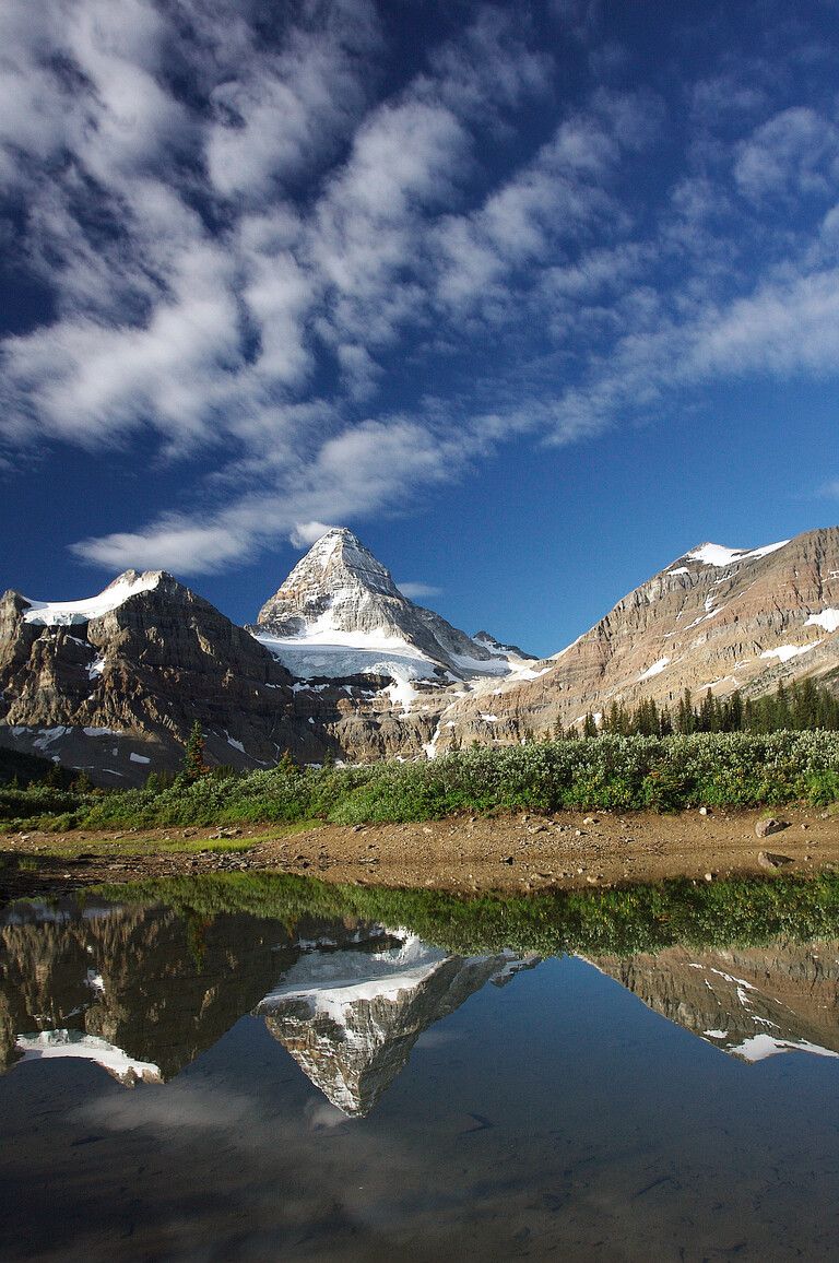
Mount Assiniboine Park
Park phone
1-403-678-2883
Current notices from the source
Hazards due to wildfire damage — There are significant risks associated with entering areas that have been burnt over by the 2017 wildfires. Potential risks could include: danger trees and overhead hazards – the integrity of trees whose trunks, roots or branches have been damaged by wildfire is unreliable terrain instability resulting in landslides and falling or shifting debris and rock amplified runoff after rainfall or snowmelt which could result in a rapid increase of water course depth and flow rates or flooding conditions ash pits – may be deep and difficult to see respiratory effects caused by breathing soot and charcoal for extended periods of time Post-wildfire hazards may last for several years or longer after a wildfire and may be triggered at any time with little or no warning.
Watercraft and fishing equipment banned to combat transmission of invasive species — To help combat and mitigate the transmission of aquatic invasive species, effective immediately, the following fishing equipment and watercraft is banned in lakes, rivers, and creeks in Mount Assiniboine Park: Watercraft Belly boats Stand up paddleboards Dinghies Boats Fishing Equipment Wading bibs/pants - all types (neoprene, breathable, rubber) Wading boots - all types (felt sole, rubber sole) Park visitors failing to comply with these measures are subject to violations and fines under the Park Act . Park visitors are reminded to clean, drain, and dry all immersible water equipment prior to entering the park. To learn more about aquatic invasive species and provincial measures being taken to mitigate tra
Clean all equipment to help prevent the spread of aquatic invasive species — BC Parks is seeking your help to prevent the introduction of aquatic invasive species into this park. Please adhere to the following measures. Clean plants, animals, mud from any watercraft and equipment before storing it or moving it into this park. Drain all water from any watercraft and equipment before storing it or moving it into this park. Dry all parts of your watercraft and equipment completely before storing it or moving it into this park. Recreational fishing gear should always be cleaned before and after entering this park. This includes waders, boots, fishing rods and lines, and other angling equipment. Never move species, organisms, or water from one body of water to another. This includes all fish sp
It is illegal to transport watercraft with the drain plug still in place — Before transporting a boat or other watercraft, owners/operators must remove the drain plug and drain all water on dry land including all internal compartments such as ballasts, bilges, and live wells. Why is this important? Whirling disease has been detected in Yoho National Park in B.C. and containment and prevention is critical. Read more information on the gov.bc.ca whirling disease webpage .
Be prepared for heavier snow conditions in 2026 than typically seen early in the season — Trail report, June 11, 2026 The hiking trail from Mount Shark looks to be clear of snow until about the warden cabin (Banff National Park), where snow patches begin along with many wet sections. The trail is fully covered in snow by the time you start climbing Assiniboine Pass. Wonder Pass has higher than average snowpack this year, and hikers can expect isothermic conditions. Snow depth at Mount Assiniboine Lodge averaged at 50 cm in addition to Magog Campground. Special note Sunshine Village is opening for skiing June 20 to July 5 due to high snowpack levels this year. Visitors accessing Mount Assiniboine Park from Sunshine Meadows should note that gondola/lift access will only be available to skier
Citadel Pass Trailhead access, June 20 to July 5 — Visitors planning to access the Sunshine Meadows area of Mount Assiniboine Park, including the Citadel Pass Trailhead and Porcupine Campground, should be aware that gondola and chairlift access will not be available from June 20 to July 5 due to a summer skiing program at Sunshine Village. Sunshine Village has advised that a hiking route from the village to the Citadel Pass Trailhead will remain available. However, hikers should be prepared for challenging conditions, with snow depths of up to 2 metres remaining on some sections of the trail.
Road closure, Highway 742 (Canmore Hill to Kananaskis) — Park visitors looking to access Mount Assiniboine Park via Mount Shark Trailhead and/or Heli Pad should note that Highway 742 is closed at Canmore Hill and not expected to reopen until Mid-July. If park visitors are planning to fly from Mount Shark, it is recommended to give an additional 2 hours of travel time from Canmore to the Mount Shark Helipad via Highway 40 (south through Kananaskis). Please check Alberta 511 detour information and closure updates.
Campgrounds in this park
- Magog Lake
- Naiset Huts
- O’Brien Meadows
- O’Brien Meadows Horse Campground
- Og Lake
- Police Meadows Cabin
- R.C. Hind Hut
- Surprise Creek Cabin
- Porcupine Campground
Activities the source lists
- Horseback riding
- Hunting
- Pets on leash
- Fishing
- Wildlife viewing
- Climbing
- Hiking
- Winter recreation
Facilities as published
- There are pit toilets at each of Mount Assiniboine’s designated campgrounds. There are no flush toilets anywhere in the park.
Camping information as published
- There is a group campsite at O’Brien Meadows that can accommodate 15 to 25 people. It has food storage lockers and there is a creek nearby for water. Open fires are prohibited. This groupsite cannot be booked through the BC Parks reservation service. All reservations must be made through Assiniboine Lodge . A minimum party of 15 people is required to book this groupsite.
- There are approximately 75 backcountry campsites in Mount Assiniboine Park. BC Parks offers reservable campsites at Magog Lake and Og Lake in the core area, and Porcupine Campground near Citadel Pass. First come, first served sites are available at Mitchell Meadows and Rock Lake near Ferro Pass. BC Parks now requires reservations for backcountry camping at Magog Lake, Og Lake, and Porcupine campgrounds during peak season. For detailed information on reservable dates and how to make a booking, see the Mount Assiniboine Park reservations page. Backcountry camping fees Camping fees (per night) $25 per adult (16+) $5 per youth (6 to 15) Free for children under 6 Non-resident fee $20 per adult (16+) per trip within the park Additional fees apply for reservations. For more information on fees and on qualifying for different rates, visit the camping fees page. Core-area camping Magog Lake The largest and most popular camping area in the park is on a bench above the west side of Magog Lake. This campground has 40 tent pads, a semi-enclosed cooking shelter, and an open-air cooking area. There are also several food storage lockers, two grey-water pits, three water taps, and four pit toilets. Og Lake There is a campground at the north end of Og Lake, approximately 5 km from Magog Lake. This campground has 10 tent pads, an outhouse, and a central cooking area. The cooking area includes food storage lockers and a grey-water pit. Water is available from Og Lake. Reservations are required for these campgrounds during peak season. For more information, see the Mount Assiniboine Park reservations page. Non-core areas Porcupine Outside the park’s core area, BC Parks offers reservable backcountry camping at Porcupine Campground. This campground has 10 reservable tent pads. It also has a pit toilet, bear caches, and a kitchen area. Reservations are required for Porcupine during peak season. For information, see the Mount Assiniboine Park reservations page. Other non-core areas Several
- There are several rustic cabins located in the more outlying areas of Mount Assiniboine Park. For detailed information on specific cabins, see the campgrounds, huts, and shelters information sheet [PDF] . First come, first served cabins There is a rustic public cabin at the Surprise Creek-Simpson River confluence. Another is in Police Meadows. These cabins are exclusively available for use on a first come, first served basis. We recommend bringing a tent in case the cabins are already occupied when you arrive. No camping fees or transaction fees are charged to stay in first come, first served cabins. Reservable cabins The Naiset Huts and R.C. Hind Hut in the core area of Mount Assiniboine are open to the public and can be reserved through Assiniboine Lodge . Reservations cannot be made through the BC Parks reservation service. Reservations for the Naiset Huts are recommended in summer and required in winter. When not reserved, these cabins are often available for use on a first come, first served basis. We recommend bringing a tent in case they are full. Nightly cabin camping fees Cabin user fee per person $30 per night (including transaction fee) Cabin user fee per family (Naiset Huts only) $50 per night (including transaction fee) A $20 fee is added for anyone who is not a B.C. resident. For more information, visit the non-resident fee section of the camping fees page.
Official maps
Amenities
Only amenities the source actually states are listed. Unknown is never shown as No.
Camping
Only camping types present in the source record.
Setting & surroundings
What's around this campsite
Official park information
Published by the land manager as being at or associated with this place. These are stated facts, not measured distances.
Water
Land & terrain
Source: BC Parks (official park data)
Verified nearby features
Loading verified geographic features…
Activities
Sourced only — activities are never inferred.
Environment and Climate Change Canada
Weather
Forecast for the Mitchell Meadows Campground coordinates. Values ECCC does not publish stay blank rather than being estimated.
Resolving the ECCC forecast for these coordinates…
Staying reachable
Connectivity
Carrier coverage comes from official FCC filings for this coordinate; Starlink information comes from Starlink's own pages. Nothing here is estimated from terrain, land ownership or nearby towns.
Reading stored coverage sources…
Agency fire orders
Fire conditions
Published fire restriction orders from the managing agency, matched to these exact coordinates. Fire permission is never inferred from land ownership, campground type or weather.
Checking agency fire orders for these coordinates…
Nearby services
Fuel, water, dump, supplies and more
Straight-line distance from the campground coordinates. Mapped places only — never inferred.
Looking up mapped services within 25 miles…
Solar
Off-grid power
Will you make enough power to stay comfortably off-grid here? Modelled from published solar climatology for these exact coordinates, credited in the details.
Modelling solar for these coordinates…
Is this place right for you?
Experience & practicality
Two transparent read-time scores. Unknown facts never count for or against a place, and a score is never used as filter evidence.
Experience
Published recreation and setting.
5.3/ 10
Documented depth: 8.5 of 16 evidence weight, from 5 published facts. A low number means little is published, not that the place is poor.
Why
- Hiking
- Fishing
- Wildlife watching
- Horseback riding
- Hunting
Practicality
Published logistics: access, cost, facilities.
—/ 10
Not enough data. Only 1 relevant fact has been published for this record, so no score is shown rather than an invented one.
Why
- Pets allowed
Partially supported: only one of the two dimensions has enough published evidence, so this record is not presented or ranked as the equal of a fully documented one.
Methodology nmr-score-3.0.0. Park-level activities feed Experience only; campsite facts feed Practicality only. Experience measures how much recreation and setting evidence is published; Practicality is the published positive share scaled by how much of the logistics catalogue has been documented, so a handful of positives can no longer read 10/10. Unknown is never treated as a no. Neither dimension is used to filter search results, and “Best” ordering ranks fully supported records above partially supported ones.
Overview
Why this place?
- Campground.
- Located in East Kootenay, BC at 6,621 ft.
- Source lists 5 recreation activities here.
- No source publishes pricing for this location, so cost is unknown.
Photos
What it looks like
Imagery published by the managing source for this record, plus verified traveler photos.
Official imagery
Traveler photos
No traveler photos here yet. A photo you upload is reviewed before it appears publicly.
Community · time-sensitive
Community reports
What travelers found on the ground, with the date they were there. Conditions change fast, and a report never replaces the official information above.
Loading community reports
Data & trust
Source confidence
Low
Confidence describes how well the ingested sources agree for this record. Verification is a separate state: Unverified.
Source
OpenStreetMap — Canadian campsites
Last source update
Aug 18, 2026
Source record
#node/7952346566
Community · traveler experience
Traveler reviews
Written by travelers who checked in here. These are personal experiences, not official campsite information, and they never change the sourced facts above.
Loading traveler reviews
Travelers here
Talk with travelers heading to Mitchell Meadows Campground. Community conversation — not verified site information. Report conditions through the report form so they can be checked.
Nearby and related camping
- McBride's Camp -Br14Division No. 15 · AB · 7 mi away
- Spray Lakes West CampgroundDivision No. 15 · AB · 14 mi away
- McLeod Meadows CampgroundEast Kootenay · BC · 16 mi away
- Burstall Campground - Us18Division No. 15 · AB · 16 mi away
- Ribbon Lake Backcountry CampgroundDivision No. 15 · AB · 19 mi away
- Lillian Lake Backcountry CampgroundDivision No. 15 · AB · 19 mi away