
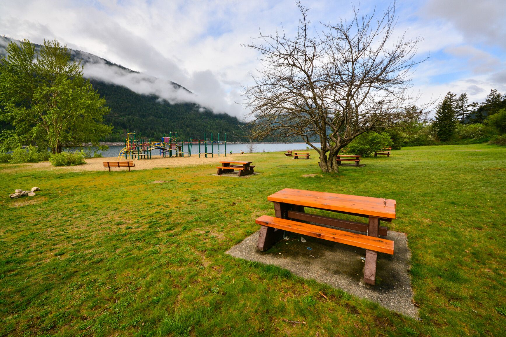
Syringa Main Campground
Central Kootenay · BC
Source: OpenStreetMap — Canadian campsites · imported Aug 17, 2026
Decide fast
Fire conditions
Agency fire orders are checked live — open the section for the current stage and what it allows.
Verified check-in
Checking your traveler account…
Only an approximate position is stored, and never shown to other travelers.
The essentials
Key campground facts
Identity-level facts as published by the source record. Fields no source publishes are left out rather than shown as Unknown.
Price
Price not published
Type
Campground
Camping status
Unknown
Land manager
RAP Park Contracting Ltd.
Sites
61 sites (stated by the source)
Facility phone
+1-250-352-0015;+1-250-825-4212
Know before you go
No conditions or restrictions are recorded for this location yet. Check the managing agency before you go.
Can you camp here?
Camping legality
Checking land status and camping rules…
Getting there
Access and vehicle suitability
No source publishes road or vehicle information for this location. Road conditions and clearance are never estimated — contact the managing agency before towing or driving in.
Where it is
Location
Loading map
Placing your camping results on the map.
Province / territory
BC
County
Central Kootenay
Elevation
1,493 ft
Coordinates
49.35001, -117.88904
Straight from the source
Published record details
Statements the source record publishes, shown as published. Anything it does not publish is left out rather than shown as Unknown.
Park size
4538 ha
Year established
1968
Official park name
Syringa Park
Park phone
+1-250-352-0015;+1-250-825-4212
Park phone (off season)
1-250-365-6945
Current notices from the source
Volunteer Host Opportunity — Syringa Provincial Park offers volunteer host opportunities
Boil water advisory in effect — A boil water advisory is in effect until further notice. Boil, filter, or treat water before use.
Campgrounds in this park
- Bighorn Campground electrified sites 62-70
- Bighorn Campground sites 71-86
- Bighorn day-use area
- Main Campground sites 1-61
- Sturgeon Point boat launch
- Sturgeon Point day-use area
- Sturgeon Point groupsite
Activities the source lists
- Hiking
- Canoeing
- Fishing
- Swimming
- Pets on leash
- Cycling
- Waterskiing
- Windsurfing
- Hunting
- Interpretive programs
- Kayaking
Facilities as published
- This park has three day-use and picnic areas. As Syringa Park is on a reservoir, the water does fluctuate from spring through fall. The water level is low in May, rises in June and is at full pond for July, August and September. The upper portion of the beach is sand with the lower portion rocky, which is mostly exposed at low water. Barbeque stands and fire rings are not available. The main picnic area is located northwest of the campground along the lake. The beach is 250 metres long with 30 picnic tables located on a raised partially shaded grassy terrace in front of the beach. A toilet and change house, two pit toilets and water taps are available for day users. This day-use area is the largest in the park, with a paved parking lot that can accommodate 220 vehicles. As indicated by its name, Boat Launch day-use area with its 150-metre beach, six picnic tables and four pit toilets can be found at the boat launch in the south end of the park just past the park entrance. Camping day-use area is located in front of the campground and is primarily used by campers. The beach is 50 metres long and has seven tables. The campground washrooms and water taps are nearby. This day-use area hosts the only adventure playground in the park. The playground is set in sand with a swing set, monkey bars, slide and spring horse.
- Two sets of pit toilets and two toilet buildings are conveniently located throughout the campground. Main beach day-use area has two pit toilets and one toilet building. Boat Launch day-use area has four pit toilets.
- Cold well water is available for cooking and drinking. Four water taps are located throughout the campground, with two each at both the day-use area and boat launch. Taps are shut off during the off-season.
- Accessibility information is available for this park.
- An adventure playground with swing set, monkey bars, platforms, slide and spring horse is located in the campground area near Campers’ Beach. The equipment is set in sand.
- A doublewide, concrete boat launch at the southeast end of the park has a large, gravel vehicle and boat trailer parking area. The parking lot has capacity for 60 vehicles. Boat trailers can be parked overnight and boats are sometimes left in the water or beached, but the shoreline offers no protection against weather changes. Visitors do enjoy waterskiing and windsurfing.
- A sani-station and dump is available during the collecting season and is located just past the gatehouse. Sani-station use fee: $5 per discharge
- The Big Horn RV sites 62 to 70 have been electrified. Sites 62 to 68 have 50amp. Sites 69 and 70 have 30amp service. All are good sized and have fire pits. All sites may be reserved . An additional service charge of $7 per night applies to these sites regardless of whether electrical service is used.
- Campfires are allowed and campfire rings are provided at each campsite. We encourage visitors to conserve wood and protect the environment by minimizing the use of fire and using campstoves instead. Firewood can be purchased in the park or you may bring your own wood. Fees for firewood are set locally and may vary from park to park. To preserve vegetation and ground cover, please don’t gather firewood from the area around your campsite or elsewhere in the park (this is a ticketable offence under the Park Act) . Dead wood is an important habitat element for many plants and animals and it adds organic matter to the soil.
- There are showers at this park.
Camping information as published
- Are you planning a family reunion, church outing, youth trip or a gathering of friends? The Sturgeon Point group site is available to book up to 12 months in advance. The group campsite is open during the main camping season. Nightly group camping fees Group camping $120 base fee $5 per adult (16+) for minimum 15 adults $1 per youth (6-15) Free for children under 6 Youth group camping $1 per person for minimum 12 people $50 minimum, $150 maximum To qualify for youth group camping, your party must be associated with a school, recreation centre, or non-profit youth organization located in B.C. To learn more, see the group camping page. A $20 fee is added for anyone who is not a B.C. resident. For more information, visit the non-resident fee section of the camping fees page.
- The park has two campgrounds with vehicle-accessible sites. All the sites are gravel and the road in the Main campground is paved, while the road in Big Horn is packed gravel. There are no pull through campsites, however, all the sites in Main campground are considered large and will accommodate bigger rigs. The Big Horn RV sites are generous, back in, gravel pads with electrical service. The Big Horn Loop sites are on the smaller size, more suitable for tents, campers and smaller RVs. All sites provide limited parking for extra vehicles. The Main Campground is one large loop with one cross road at its center. The Big Horn is adjacent to the day-use area with most sites overlooking the lake. The majority of the sites are shaded in a mixed forest of fir and pine. The park offers services during the peak season of May to September. Campsite reservations are accepted and first come, first served sites are also available. Visitors can select any non-reserved site and staff will come to collect fees. A gatehouse with a pay phone is located about 2 km from the park entrance sign. The closest store is Scottie’s Marina 1.5 km from the park. Frontcountry camping fees (per party) Peak season rate $37.50 per night Shoulder season rate $26 per night $18.75 per night (B.C. seniors’ rate) Non-resident fee $20 per stay Additional fees apply for reservations. For more information on fees and on qualifying for different rates, visit the camping fees page.
Amenities
Only amenities the source actually states are listed. Unknown is never shown as No.
Camping
Only camping types present in the source record.
Setting & surroundings
What's around this campsite
Official park information
Published by the land manager as being at or associated with this place. These are stated facts, not measured distances.
Water
Land & terrain
Source: BC Parks (official park data)
Verified nearby features
Loading verified geographic features…
Activities
Sourced only — activities are never inferred.
Environment and Climate Change Canada
Weather
Forecast for the Syringa Main Campground coordinates. Values ECCC does not publish stay blank rather than being estimated.
Resolving the ECCC forecast for these coordinates…
Staying reachable
Connectivity
Carrier coverage comes from official FCC filings for this coordinate; Starlink information comes from Starlink's own pages. Nothing here is estimated from terrain, land ownership or nearby towns.
Reading stored coverage sources…
Agency fire orders
Fire conditions
Published fire restriction orders from the managing agency, matched to these exact coordinates. Fire permission is never inferred from land ownership, campground type or weather.
Checking agency fire orders for these coordinates…
Nearby services
Fuel, water, dump, supplies and more
Straight-line distance from the campground coordinates. Mapped places only — never inferred.
Looking up mapped services within 25 miles…
Solar
Off-grid power
Will you make enough power to stay comfortably off-grid here? Modelled from published solar climatology for these exact coordinates, credited in the details.
Modelling solar for these coordinates…
Is this place right for you?
Experience & practicality
Two transparent read-time scores. Unknown facts never count for or against a place, and a score is never used as filter evidence.
Experience
Published recreation and setting.
7.2/ 10
Documented depth: 11.5 of 16 evidence weight, from 6 published facts. A low number means little is published, not that the place is poor.
Why
- Hiking
- Fishing
- Kayaking / canoeing
- Swimming
- Boating
- Hunting
Practicality
Published logistics: access, cost, facilities.
—/ 10
Not enough data. Only 3 relevant facts have been published for this record, so no score is shown rather than an invented one.
Why
- Cost is published
- Dump station
- Pets allowed
Partially supported: only one of the two dimensions has enough published evidence, so this record is not presented or ranked as the equal of a fully documented one.
Methodology nmr-score-3.0.0. Park-level activities feed Experience only; campsite facts feed Practicality only. Experience measures how much recreation and setting evidence is published; Practicality is the published positive share scaled by how much of the logistics catalogue has been documented, so a handful of positives can no longer read 10/10. Unknown is never treated as a no. Neither dimension is used to filter search results, and “Best” ordering ranks fully supported records above partially supported ones.
Overview
Why this place?
- Campground managed by RAP Park Contracting Ltd..
- Located in Central Kootenay, BC at 1,493 ft.
- Source lists 8 recreation activities here.
- No source publishes pricing for this location, so cost is unknown.
Photos
What it looks like
Imagery published by the managing source for this record, plus verified traveler photos.
Official imagery
Traveler photos
No traveler photos here yet. A photo you upload is reviewed before it appears publicly.
Community · time-sensitive
Community reports
What travelers found on the ground, with the date they were there. Conditions change fast, and a report never replaces the official information above.
Loading community reports
Data & trust
Source confidence
Low
Confidence describes how well the ingested sources agree for this record. Verification is a separate state: Unverified.
Source
OpenStreetMap — Canadian campsites
Last source update
Aug 18, 2026
Source record
#way/633770859
Community · traveler experience
Traveler reviews
Written by travelers who checked in here. These are personal experiences, not official campsite information, and they never change the sourced facts above.
Loading traveler reviews
Travelers here
Talk with travelers heading to Syringa Main Campground. Community conversation — not verified site information. Report conditions through the report form so they can be checked.
Nearby and related camping
- Bighorn CampgroundCentral Kootenay · BC · 1 mi away
- Nancy Greene CampgroundKootenay Boundary · BC · 7 mi away
- PAULSON CROSS-COUNTRYKootenay Boundary · BC · 9 mi away
- Mud Lake Recreation SiteKootenay Boundary · BC · 10 mi away
- Pass Creek Regional ParkCentral Kootenay · BC · 10 mi away
- BLACKJACK CROSS COUNTRYKootenay Boundary · BC · 15 mi away